

5 bedroom detached house for sale
Key information
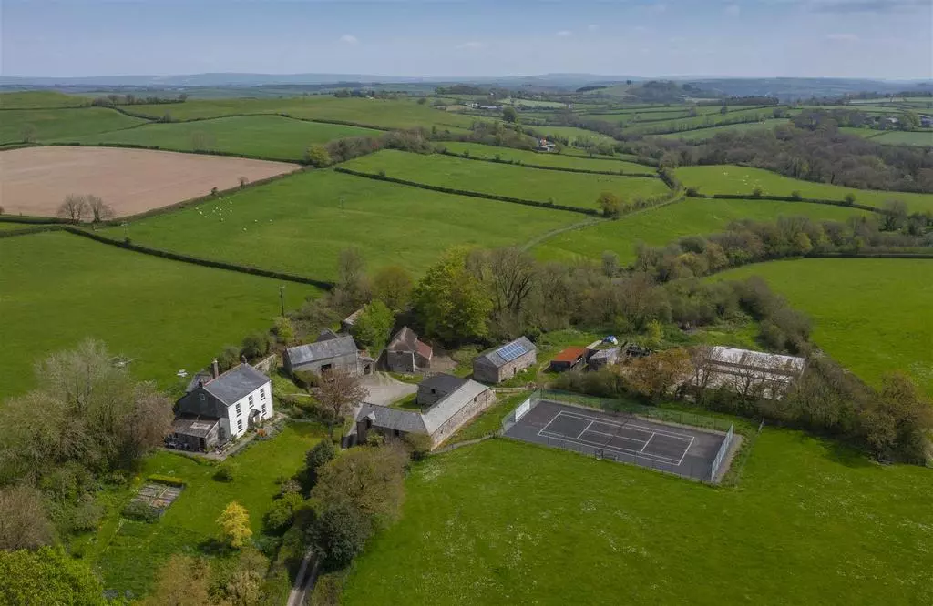
Property description & features
- A characterful house (not Listed) with a south facing aspect, high ceilings and period features throughout.
- Extensive grounds including a garden, tennis court, pond and a traditional mixed orchard
- Stone and cob barns for conversion with planning consent in place to create four detached homes
- Further modern building with potential for alternative uses including residential conversion
- Historic lime workings including an 18th century lime kiln, lakes and broadleaf woodland
- Productive pasture land which is mostly south facing and surrounds the farmstead
- 156.93 acres (63.51 hectares)
- EPC : D
- Council Tax: Band F
- FREEHOLD
Situation - West Irishborough lies in a peaceful rural location in north Devon, surrounded by gently rolling countryside and near to the villages of Chittlehampton and Swimbridge.
Chittlehampton has the notable St. Hieritha's parish church, Post Office & general store, active cricket and football clubs and the popular The Bell Inn pub. Swimbridge also has a fine church (of which Jack Russell, the breeder of terriers was vicar), a primary school and The Jack Russell pub.
The market town of South Molton is within 6.5 miles and has a more comprehensive range of shops, bakeries, butchers, primary and secondary schools, a supermarket as well as weekly livestock and farmers markets. Barnstaple is within 6 miles.
West Buckland School is within 6 miles and there is a bus route to Blundells School, Tiverton nearby.
The A361 (North Devon Link Road) can be accessed within 4.5 miles and provides a link to the M5 motorway at Junction 27, nearby to which is Tiverton Parkway rail station with mainline services to London Paddington. Umberleigh Station (4.8 miles) is on the picturesque Tarka Line which runs between Barnstaple and Exeter.
Exmoor National Park is nearby and is known for its hundreds of square miles of superb unspoilt scenery, and the North Devon surfing beaches of Putsborough, Saunton, Croyde and Woolacombe are all within reach.
For golf, The Royal North Devon Golf Club and Saunton Golf Club are both approximately 15 miles away.
Introduction - West Irishborough lies in a private position at the end of its own drive and occupies a south-facing position with protection and privacy provided by the farmstead being surrounded by the farm's land.
In total West Irishborough extends to 156.93 acres (63.51 hectares) providing an opportunity to create additional dwellings for multiple generational living or to provide letting income, alongside an attractive existing home and a diverse mixture of land uses for farming and recreational purposes.
The substantial house is a comfortable family home which is surrounded by its gardens, an orchard and a tennis court. The traditional stone and cob barns have planning consent for conversion to create four residential dwellings with additional buildings with potential for alternative uses.
The farm land is all grass with some fields suitable for cultivation and added diversity is found in established lakes, mature woodland and the historic lime kiln. There is stabling for six or more horses with some of the northernmost fields suitable for horse grazing.
The present owner has run enjoyable and informal shoot mornings for four guns and though otter dependent, there are coarse fish in two of the lakes and some years ago there were trout in the third lake.
As West Irishborough has not been intensively farmed for many years, the wildlife is varied with the current owners seeing kingfisher, teal, otters, barn and tawny owls.
Historical Note - The name Irishborough comes from the Saxon 'earnesborough' meaning 'home of the Eagle' with the earliest reference occurring in the Pipe Rolls of 1175.
An earlier resident of Irishborough, Sir John Mules built the north aisle of Swimbridge Church and lime quarrying took place over many centuries with the earliest recorded date being 1588.
The present house was built around 1850 whereas the barns range from the unknown-dated thatched poundhouse, through the threshing barn with graffiti of 1765 to the later 19th century stables.
Lot 1: 85.18 Acres (34.48 Hectares) -
West Irishborough House - Occupying a south-facing position, the house at West Irishborough is not listed and provides generous accommodation for a family (3,264 sq. ft) with period features throughout including high ceilings, picture rails and sash windows.
The attractive house is of stone construction which is rendered on the front elevation and slate hung on the western elevation.
On the ground floor the front door opens into the entrance hall, with a flagstone floor, a fitted book shelf and stairs to the first floor.
The front sitting room has a stone fireplace housing a wood-burning stove with cupboards and bookshelves either side. The second sitting room has a decoratively tiled Victorian style fireplace.
The kitchen, with a tiled floor and the former fireplace now houses an electric Belling oven and hob. This opens into the dining area which overlooks the garden and has a Victorian style fireplace and a flagstone floor.
The back kitchen has a former fireplace, a butler's sink and a w.c. Additional rooms include a study with a door through to a garden store.
The stairs lead up to a half landing off which there is a double sized bedroom and a shower room with a walk-in shower and w.c.
The stairs continue up to the main landing where there are four further bedrooms and a large bathroom with a bath, walk-in shower and w.c.
A second set of stairs continue up to the former attic space which is used as a recreational room.
Outside - The south-facing gardens include a gently sloping lawn enclosed with a low level hedge, a small patio and mature shrub and flower beds.
To the east of the house is a tall stone wall with a gently sloping lawn and steps down to the yard whilst to the west the gardens extend to include a pond and trees of varying ages.
Beyond the gardens is a traditional orchard which includes some cider apple, eating apple, cherry and pear trees.
The Traditional Barns - The farm buildings are positioned around the yard and have planning consent to be converted into residential dwellings.
The Stables - An attractive building with stone walls, brick surrounding the openings and a slate roof.
Planning consent is in place to convert this building to a substantial house which on the ground floor will have a very spacious entrance hall, a kitchen, dining room, living room, utility room and w.c. with one double bedroom and a bathroom.
On the first floor the proposed accommodation is for three double bedrooms each with an en-suite shower room and the master bedroom to include fitted wardrobes and a dressing room.
Outside there is provision for a large, landscaped garden to replace the existing tennis court, a double garage and parking for four cars.
The Threshing Barn & Roundhouse - A characterful barn which includes the stone threshing barn and former roundhouse with a slate roof.
The approved plans for the ground floor are for an entrance hall with the main stairs, a living room, a kitchen, a utility and boot room with w.c, a dining room, a snug / reading room and a shower room which is accessible from the third bedroom.
On the first floor the plans are for three double bedrooms, two of which will have en-suite shower rooms.
Outside there will be a large garden which extends around to the north and east, a double garage and parking for two cars.
The Poundhouse - This fascinating barn which includes a delightful first floor room, has a thatched roof and is part lime rendered over the cob walls and part stone construction.
The consented accommodation on the ground floor includes an open plan living and dining space which opens on to decking, a snug, a kitchen and a boot room with w.c.
On the first floor there will be two bedrooms, one with an en-suite shower room and a further bathroom and landing.
Outside space is to the south and east, with a double garage and parking for two cars.
Linhay Barn - This barn is currently open-fronted with buttresses stone walls and a slate roof.
On the ground floor the planning consent is for a living room, reception room, a kitchen / dining room, utility room and on the first floor there will be three bedrooms, one with an en-suite shower room and a further bathroom.
Outside there will be a large garden and parking for two cars.
General Purpose Building - 18.15m x 9.16m. Steel frame, concrete floor, box profile sheet cladding and roof.
A planning application has been submitted to convert this barn to a dwelling under Class Q.
The proposed accommodation is for a single storey converstion with three bedrooms, three bath/shower rooms, an open plan kitchen/dining room and living space, office and utility room. Outside the plans are for a garden and parking
Further details are available from the agents.
Further Buildings - Woodstore: Timber frame with corrugated tin cladding and a concrete floor. Part of this is to be demolished as a condition of the approved planning consent.
Store: Approx. 6.53m x 3.90m. Corrugated tin roof.
Cubicle Shed: 17.18m x 13.49m. Timber frame, concrete floor, box profile sheet roof.
The Land - The land within Lot 1 includes productive pasture fields which lie to the east, north and west of the farmstead.
These fields are gently sloping with a south-facing aspect and are suitable for grazing, mowing or growing cereal and forage crops.
The soils are described as freely draining slightly acid loamy soils and slowly permeable seasonally wet acid loamy and clayey soils classified as Grade 3.
Known as the Rubble Hills, at the eastern boundary of the farm are the former lime workings which remain visible and accessible, broadleaf woodland and three lakes and ponds which are currently used by the owners for swimming, fishing and boating.
The woodland beside the stream running down from the farmstead to the Rubble Hills known as 'the Low Place' offers a further two lakes and ponds.
Lot 2: 71.74 Acres (29.03 Hectares) - Lot 2 comprises the farm land to the south of the farmstead which is currently all used for grazing and mowing.
These fields are either level or gently sloping with a mostly south-west facing aspect and are enclosed by mature hedgerows.
Access is via an existing gateway on the drive to West Irishborough and there is a small area of woodland on the eastern boundary which runs down to a flowing stream.
General Remarks -
Services - Private water (borehole with UV filter). Mains water. Mains electricity. Private drainage (Marsh sewage treatment plant installed in July 2020). Broadband (Airband). Oil-fired central heating.
Solar PV panels installed March 2011 with a 25 year Feed in Tariff contract. During 2023 this generated 3,496 units paying £2,418.
If Lot 1 and Lot 2 are sold separately, the purchaser of Lot 2 will be required to install their own borehole.
Tenure - The farm is owned freehold and is registered on the Land Registry.
Vacant possession will be available from completion.
Land Management - The farm is within a Mid Tier Countryside Stewardship agreement until 31st December 2027.
The land is let on a grazing licence until 19th October 2024. Notice can be served to terminate this licence earlier, from 1st August.
Planning - Planning consent was approved on 5th March 2024 to convert four buildings to residential dwellings under planning reference: 77488.
A section 106 planning agreement forms part of the planning consent and outlines financial contributions which are required to be made.
A planning application has been submitted to convert the general purpose building to a dwelling (Class Q).
Further information is available from Stags.
Local Authority - North Devon District Council. [use Contact Agent Button]. ().
Council Tax Band F.
Designations - The farm is within a Nitrate Vulnerable Zone (NVZ).
Plans & Boundary Fences - A plan, which is not to scale and is not to be relied upon, is attached to these particulars. Purchasers must satisfy themselves by inspection or otherwise as to its accuracy.
The purchaser of Lot 2 will be required to erect a new fence between fields 3516 and 3308.
Sporting & Mineral Rights - The sporting and mineral rights insofar as they are owned, are included with the freehold of the whole farm.
Fixtures & Fittings - All fixtures and fittings, unless specifically referred to within these particulars, are expressly excluded from the sale.
All remaining diesel and domestic fuel oil shall be taken over at cost price. Any logs and unused fencing materials are available to purchase.
Wayleaves & Rights Of Way - The property is sold subject to and with the benefit of any wayleave agreements and any public or private rights of way or bridleways etc.
There is a public footpath passing through the farm, away from the house.
There is no annual payment for the two electricity pylons which are situated on land belonging to West Irishborough.
Viewing - Strictly by prior appointment with Stags. Please call:[use Contact Agent Button] or[use Contact Agent Button] to arrange an appointment.
What3words - Reference /// passions.spilled.resettle
Warnings - Farms and land can be dangerous places. Please take care when viewing the property, particularly in the vicinity of farm buildings and livestock.
Disclaimer - These particulars are a guide only and should not be relied upon for any purpose.
Property information from this agent
Places of interest
See more properties like this:
*DISCLAIMER
Property reference 32995940. The information displayed about this property comprises a property advertisement. OnTheMarket.com makes no warranty as to the accuracy or completeness of the advertisement or any linked or associated information, and OnTheMarket.com has no control over the content provided by the agent or developer. This property advertisement does not constitute property particulars. The information is provided and maintained by Stags - Exeter, Farm Agency.
OnTheMarket may have applied supplementary data to this property listing, including:
Broadband availability and predicted speed: obtained from Ofcom on March 29, 2024
Broadband speed is measured in megabits per second, with the number returned showing how fast the connection is. Each reading is based on the highest predicted speed of any major broadband network for services that deliver the download speeds. The following are the different readings that we may display:
Basic: Up to 30 Mbit/s
Super-fast: Between 30 Mbit/s and 300 Mbit/s
Ultra-fast: Over 300 Mbit/s
The data is updated three times a year. The checker results are predictions and should not be regarded as guaranteed. For more information, see: https://checker.ofcom.org.uk/en-gb/about-checker#Answer_0_2
Mobile phone signal availability and predicted strength: obtained from Ofcom on March 29, 2024
Mobile signal predictions are provided by the four UK mobile network operators: EE, O2, Three and Vodafone. Predictions can vary significantly from the coverage you may actually experience as a result of local factors (especially terrain). Ofcom has tested the actual coverage provided in various locations around the UK to help ensure that these predictions are reasonable. The values shown against a property can be broken down as follows:
Clear: No bars, no signal predicted
Red: One bar, reliable signal unlikely
Amber: Two bars, may experience problems with connectivity
Green: Three bars, likely to have good coverage and receive a data rate to support basic web services
Enhanced: Full bars, likely to have good coverage indoors and to receive an enhanced data rate to support multimedia services
Energy Performance data and Internal floor area
Any supplementary data should not be relied upon as forming part of any property particulars and OnTheMarket cannot be held responsible for any incorrectness in this data. See here for more information.