

Woodland for sale
Key information
Property description & features
- Tenure: Freehold
- Broadleaf woodland
- Almost 4 acres
- Views across Hereford
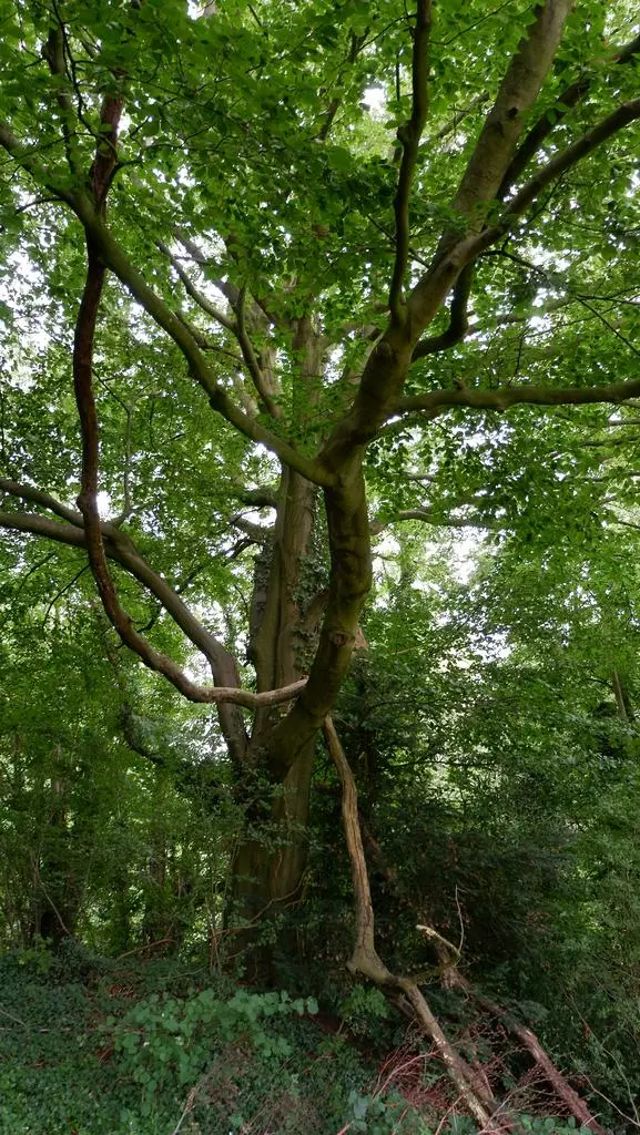
Small and manageable broadleaf woodlands like this rarely come to market in Herefordshire, so this is a great opportunity to secure a small woodland. This is a beautiful uneven-aged mixed broadleaf woodland on the side of Dinedor Hill with views right across Hereford, to the hills beyond. The ground slopes gently away from the road, but there are level areas.
Magnificent oak, ash, and beech trees are dotted around the wood, with a good canopy of mature trees, and some young natural regen. The canopy ensures that there is very little bramble, and only the small holly interferes with the ease of walking around the wood. In spring there are daffodils, anemones, and bluebells in patches throughout the wood.
From the lower parts of the wood, and from the road, there are impressive views, looking across the valley towards Hereford. A network of well established paths cross the woodland. These paths appear on the Ordnance Survey map of the wood as far back as 1888.
Access: The woodland is situated near the end of a no through road that serves a few houses further along the road. There is scope for reinstating/improving the vehicular track, which used to run through the upper part of the woodland. A flat area, adjacent to this track, could be used for a caravan, log cabin or any other purpose subject to the relevant planning consents being obtained.
Boundaries: The external boundary of the wood to the north is the fence line, and to the west it is the private road (although it appears the road is included within the wood). The south eastern boundary is a footpath (which is part of the adjacent woodland). The majority of the eastern boundary is the main track into the wood, and is part of the woodland.
Common Land: The woodland is designated as common land, which gives rights of public access on foot, but no other rights. The current owner has never seen, or known of, walkers accessing the woodland itself: Public footpaths bordering the land are well maintained, thereby minimising the desire to roam elsewhere.
Sporting rights: Included in the sale
Mineral rights: Included in the sale
Public footpaths: The path that runs along the southern edge of the wood is a public footpath. A second footpath runs along the main track at the north-eastern edge of the wood, and then along the northern boundary.
Local area: The woodland is only three miles south of Hereford, situated near the end of a no through road. Dinedor Camp, a prehistoric hill fort, lies just a few hundred metres to the south east of the wood.
Please note, while this wood is not suitable for residential development, other uses such as summer camping may well be appropriate.
VIEWING: Please register your interest in this wood with the selling agents by email ([use Contact Agent Button]) before viewing.
DIRECTIONS
From the North: Head south from Hereford town centre on the A49. Turn left at the traffic lights signposted Holme Lacey and at the next roundabout take the third exit onto Hoarwithy Road. Remain on this road for 1.5 miles and then turn left signposted for Dinedor. Head up the hill and then turn left at the cross roads signposted for Dinedor Camp. Follow this road up and the woodland can be seen on your left hand side, identified by our For Sale board.
You should be able to park just past the entrance to the wood and our For Sale board.
From the South: as you come into Hereford on the A49, take the right turn at traffic lights signposted Holme Lacy, then continue as above.
- Postcode for Satnav: HR2 6PD
- Coordinates for Satnav: 52.024861, -2.700210 (entrance track)
If navigating with a satnav using the postcode, note that the postcode is further along the road past the wood
Please note: the particulars with plans, maps, descriptions and measurements are for reference only and although carefully checked we cannot guarantee their accuracy and do not form part of any contract. Any intending purchasers must satisfy themselves by inspection or otherwise as to the correctness of these particulars.
Places of interest
See more properties like this:
*DISCLAIMER
Property reference WWM-Dinedor. The information displayed about this property comprises a property advertisement. OnTheMarket.com makes no warranty as to the accuracy or completeness of the advertisement or any linked or associated information, and OnTheMarket.com has no control over the content provided by the agent or developer. This property advertisement does not constitute property particulars. The information is provided and maintained by Forests - Herne Hill.
OnTheMarket may have applied supplementary data to this property listing, including:
Broadband availability and predicted speed
Broadband speed is measured in megabits per second, with the number returned showing how fast the connection is. Each reading is based on the highest predicted speed of any major broadband network for services that deliver the download speeds. The following are the different readings that we may display:
Basic: Up to 30 Mbit/s
Super-fast: Between 30 Mbit/s and 300 Mbit/s
Ultra-fast: Over 300 Mbit/s
The data is updated three times a year. The checker results are predictions and should not be regarded as guaranteed. For more information, see: https://checker.ofcom.org.uk/en-gb/about-checker#Answer_0_2
Mobile phone signal availability and predicted strength
Mobile signal predictions are provided by the four UK mobile network operators: EE, O2, Three and Vodafone. Predictions can vary significantly from the coverage you may actually experience as a result of local factors (especially terrain). Ofcom has tested the actual coverage provided in various locations around the UK to help ensure that these predictions are reasonable. The values shown against a property can be broken down as follows:
Clear: No bars, no signal predicted
Red: One bar, reliable signal unlikely
Amber: Two bars, may experience problems with connectivity
Green: Three bars, likely to have good coverage and receive a data rate to support basic web services
Enhanced: Full bars, likely to have good coverage indoors and to receive an enhanced data rate to support multimedia services
Energy Performance data and Internal floor area
Any supplementary data should not be relied upon as forming part of any property particulars and OnTheMarket cannot be held responsible for any incorrectness in this data. See here for more information.