No longer on the market
This property is no longer on the market

 Area stats
Land
Under offer
Land
Key information
Features and description
- Rarely available block of land extending to 7.86 acres
- Adjacent to one of Kent's best known vineyards
- Eccles 1 mile
- Maidstone 4.3 miles
- Rochester 5.8 miles
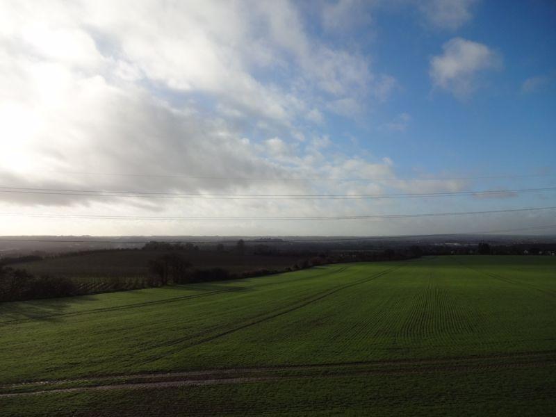
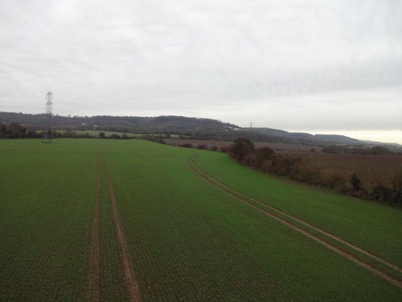
A rarely available block of land adjacent to one of Kent's best known vineyards and offering purchasers the potential amenity or viticulture use, extending to 7.86 acres (31.8 hectares).
VIEWING: At any reasonable time during daylight hours having notified the selling agent Lambert & Foster’s Paddock Wood office on[use Contact Agent Button].
DIRECTIONS: The nearest postcode to the property is ME20 7DD. From Junction 6 on the M20, proceed north on the A229 Bluebell Hill. Take the turning for Sandling, Eccles and Burham. At the T junction adjacent to the Lower Bell public house, turn left on to Rochester Road and then take the first turning on the right on to the Pilgrims Way. Proceed along the Pilgrims Way for 0.5 miles and the entrance to the land will be found on the left hand side.
WHAT3WORDS: The access point for the gateway adjacent to the northern boundary, is power.engraving.lighten. For the purposes of inspection, the best point of access on foot is via a footpath to the south, which runs from Mackenders Lane in the village of Eccles. The access point to this footpath from Mackenders Lane is to be found at warblers.scorching.auctioned.
SITUATION: The property is located on the southern side of the Pilgrims Ways at the foot of the North Kent Downs. The village of Eccles, which lies to the south has facilities including a public house, church and village recreation ground. Extensive retail and leisure facilities are available in Maidstone, Junction 6 on the M20 motorway, lies approximately 3.7 miles to the south, offering onward travel north to London and the M25, or south to the Channel Tunnel rail link, with onward connections to France.
LOCAL AUTHORITY: Tonbridge & Malling Borough Council, Gibson Building, Gibson Drive, Kings Hill, West Malling, ME19 4LZ. Telephone:[use Contact Agent Button]
DESCRIPTION: The property currently comprises part of a single arable field, which has been cultivated by a local farmer. In recent times, access has been by informal agreement with the adjoining vineyard owner, using their gated agricultural track, which runs along the northern boundary of the property. Planning consent was granted on the 12th November 2020 for the creation of a new agricultural access, to provide direct vehicular access at the northern end of the land from the Pilgrims Way. The application reference TM/20/02110/FL, together with associated plans and drawings, can be found on the Tonbridge & Malling Borough Council website.The land is of the same soil type to the adjacent Kits Coty Vineyard, being freely draining, lime rich loamy soils, typical of herb rich chalk and limestone pastures. The land is gently sloping in a south westerly aspect and is between 40 and 55 metres above sea level.Whilst being situated in a semi rural location at the foot of the North Downs, access to the A229 and onwards to the M2 and M20 motorways, is near at hand.
SERVICES: No services are connected to the land.
FOOTPATHS: The land is crossed at the northern extent by footpath MR451, which runs along the northern boundary of the land and then across the field. Public footpath MR452 lies to the west of the property.
THIRD PARTY RIGHTS: Access to the property in recent times, has been by way of an informal access arrangement with the adjacent land owner. The owners of the remainder of the arable land, which is currently cropped by a single farmer, also have an informal access arrangement with the vendor for agricultural access only. Further information is available on request from the selling agent.
OCCUPATION: The land is currently within a Cropping Licence which documents the occupation of the arable farmer, who has cultivated the land. The term date for this Licence is the earlier of the harvesting of the current Winter Wheat Crop, or the 31st August 2021. Further information can be obtained from the sole selling agent.
PARTICULARS, PLANS AND SCHEDULES:The particulars and acreages stated therein, together with the plans are believed but not guaranteed to be correct. They are given by the Agents to assist viewers but are specifically excluded from any contract and prospective purchasers must satisfy themselves as to the information contained therein. The photographs were taken in November 2020 and the particulars were also prepared in November 2020.
ANTI MONEY LAUNDERING COMPLIANCE (AML): Inaccordance with Money Laundering Regulations, we are nowrequired to obtain proof of identification for all vendors andpurchasers. You will need to supply information required for usto complete our identification checks which will include yourdate of birth, main residential address and a colour copy of yourpassport or photo driving licence. Lambert & Foster apologisefor any inconvenience this may cause, but it is a legalrequirement. Unfortunately, Lambert & Foster will not be ableto conclude a sale on your behalf to any person or people whoare unable to provide confirmation of identification. Note:Lambert & Foster currently employs the services ofSmartsearch to verify the identity and address of vendors/purchasers.
Property information from this agent
Area statistics
Crime score
Low crime
0/10
About this agent
L&F VALUES Established over 100 years ago, our firm provides the highest level of independent professional advice across the whole property spectrum in Kent and Sussex. We take pride in providing a first class service to our clients, based upon professionalism with traditional values and a modern outlook. L&F COMPANY We provide the full package of property services including; Estate Agency and Lettings, Agricultural Auctioneering, Valuation and Professional Services, Architectural and Building Surveying Services and Planning Consultancy. Our planning department is enhanced by Bloomfields, Chartered Town Planners, who have joined the firm and our merger with Handleys, takes our network of agricultural and agency offices into East Sussex.