No longer on the market
This property is no longer on the market

Land
Land
6.63 acre(s)
Key information
Tenure: Freehold
Council tax: Ask agent
Features and description
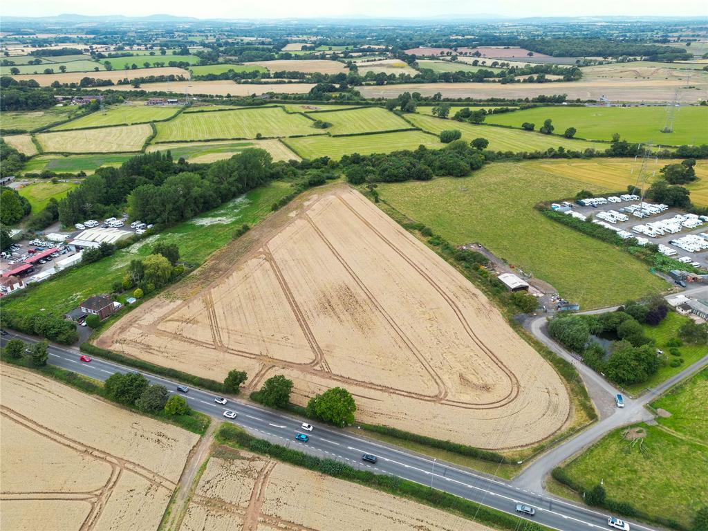
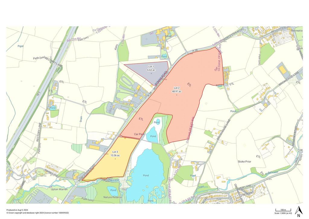
- Lot 1 Approx. 6.63 acres
An opportunity to acquire a block of productive arable land in a strategic location, with mineral deposits of sand and gravel.
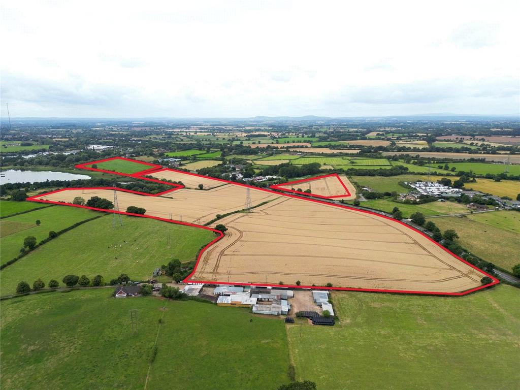
Located close to Bromsgrove and with good access from the Worcester Road, the land extends to approximately 68.96 acres (27.91 hectares).
For Sale by private treaty as a whole or in three lots.
Situation
The land situated off the Worcester Road (A38) south of Bromsgrove. There is good road frontage and various points of access. The land is strategically located being on the southern fringe of Bromsgrove and just 1.5 miles distant of Junction 5 of the M5 Motorway.
Directions
Post Code – B61 7EZ
What3Words – ///computers.whimpered.appetite
Description
Extending in total to approximately 68.96 acres, the land consists of three lots of productive arable land:
Lot 1: Extending to approximately 6.63 acres, it is located to the north of the Worcester Road. (please note that the acreage offered is smaller than the current field margins and therefore the boundaries will be different to those currently on the ground).
Land Quality and Soil Type
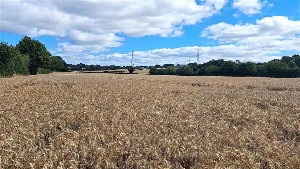
The land is mainly classified as Grade 3 with some Grade 2 soils according to the Agricultural Land Classification Map of the West Midland Region. The soil may be described as slightly acid loamy and clayey soils and are generally reasonably flexible but more suited to autumn sown crops and grassland.
Services
We understand that mains water is available. Prospective Purchasers must satisfy themselves as to the availability of services and any future connections.
Mineral Resources
A preliminary resource evaluation has been undertaken of Lot 3 ‘Swan Field’ which shows there to be approximately 142,000 tonnes of sand and gravel at a depth of between approximately 75cm and greater than 380cm below the surface. A copy of the report is available from the selling agents.
Basic Payment Scheme and Environmental Schemes
The land has historically been registered for payments under the Basic Payment Scheme and all delinked payments and entitlements relevant to the land will be retained by the Vendors and will not be available to the Purchaser on completion of the sale.
Tenure and Possession
The property is to be sold freehold with vacant possession available on completion.
The land is registered with the Land Registry under part of title number WR110119.
Ingoing Crop Valuation/Holdover
An ingoing crop valuation will not be required.
VAT
The property is not subject to VAT on the purchase so far as we are aware but reserve the right to do so.
Sporting, Mineral and Timber Rights
The sporting, mineral and timber rights will be transferred with the freehold title where owned.
Nitrate Vulnerable Zones (NVZ) & Flood Zones
The Property lies within a Surface Water NVZ Area and is subject to the usual restrictions.
A small area of the property lies within Flood Zones 2 & 3 as defined by the Environment Agency.
Overage
The land will be sold subject to an uplift provision which will specify that 25% of any increase in value due to development (as defined in Section 55 of the Town and Country Planning Act 1990) will be payable to the Vendors or their successors in title should such development occur within 20 years from the date of completion. The uplift will be payable upon the grant of planning consent.
Local Authority
Bromsgrove District Council.
Public Rights of Way, Wayleaves and Easements
The property is sold subject to all rights of way, wayleaves and easements whether or not they are defined in this brochure. There are no public footpaths crossing the land.
We understand that there is an underground medium pressure gas pipeline, an overhead National Grid Transmission high voltage ZN line and tower, and several National Grid Distribution overhead lines and underground cables including an overhead 66kV line with H-poles and a 11kV line with poles in the field. Further details are available from the selling agents.
Viewings
Viewings are possible from the Worcester Road (A38) and on foot at any reasonable time during daylight hours.
Plans and Boundaries
The plans within these particulars are based on Ordnance Survey data and provided for reference only. They are believed to be correct, but accuracy is not guaranteed. The purchaser shall be deemed to have full knowledge of all boundaries and the extent of ownership. Neither the vendor nor the vendor’s agents will be responsible for defining the boundaries or the ownership thereof.
Located close to Bromsgrove and with good access from the Worcester Road, the land extends to approximately 68.96 acres (27.91 hectares).
For Sale by private treaty as a whole or in three lots.
Situation
The land situated off the Worcester Road (A38) south of Bromsgrove. There is good road frontage and various points of access. The land is strategically located being on the southern fringe of Bromsgrove and just 1.5 miles distant of Junction 5 of the M5 Motorway.
Directions
Post Code – B61 7EZ
What3Words – ///computers.whimpered.appetite
Description
Extending in total to approximately 68.96 acres, the land consists of three lots of productive arable land:
Lot 1: Extending to approximately 6.63 acres, it is located to the north of the Worcester Road. (please note that the acreage offered is smaller than the current field margins and therefore the boundaries will be different to those currently on the ground).
Land Quality and Soil Type
The land is mainly classified as Grade 3 with some Grade 2 soils according to the Agricultural Land Classification Map of the West Midland Region. The soil may be described as slightly acid loamy and clayey soils and are generally reasonably flexible but more suited to autumn sown crops and grassland.
Services
We understand that mains water is available. Prospective Purchasers must satisfy themselves as to the availability of services and any future connections.
Mineral Resources
A preliminary resource evaluation has been undertaken of Lot 3 ‘Swan Field’ which shows there to be approximately 142,000 tonnes of sand and gravel at a depth of between approximately 75cm and greater than 380cm below the surface. A copy of the report is available from the selling agents.
Basic Payment Scheme and Environmental Schemes
The land has historically been registered for payments under the Basic Payment Scheme and all delinked payments and entitlements relevant to the land will be retained by the Vendors and will not be available to the Purchaser on completion of the sale.
Tenure and Possession
The property is to be sold freehold with vacant possession available on completion.
The land is registered with the Land Registry under part of title number WR110119.
Ingoing Crop Valuation/Holdover
An ingoing crop valuation will not be required.
VAT
The property is not subject to VAT on the purchase so far as we are aware but reserve the right to do so.
Sporting, Mineral and Timber Rights
The sporting, mineral and timber rights will be transferred with the freehold title where owned.
Nitrate Vulnerable Zones (NVZ) & Flood Zones
The Property lies within a Surface Water NVZ Area and is subject to the usual restrictions.
A small area of the property lies within Flood Zones 2 & 3 as defined by the Environment Agency.
Overage
The land will be sold subject to an uplift provision which will specify that 25% of any increase in value due to development (as defined in Section 55 of the Town and Country Planning Act 1990) will be payable to the Vendors or their successors in title should such development occur within 20 years from the date of completion. The uplift will be payable upon the grant of planning consent.
Local Authority
Bromsgrove District Council.
Public Rights of Way, Wayleaves and Easements
The property is sold subject to all rights of way, wayleaves and easements whether or not they are defined in this brochure. There are no public footpaths crossing the land.
We understand that there is an underground medium pressure gas pipeline, an overhead National Grid Transmission high voltage ZN line and tower, and several National Grid Distribution overhead lines and underground cables including an overhead 66kV line with H-poles and a 11kV line with poles in the field. Further details are available from the selling agents.
Viewings
Viewings are possible from the Worcester Road (A38) and on foot at any reasonable time during daylight hours.
Plans and Boundaries
The plans within these particulars are based on Ordnance Survey data and provided for reference only. They are believed to be correct, but accuracy is not guaranteed. The purchaser shall be deemed to have full knowledge of all boundaries and the extent of ownership. Neither the vendor nor the vendor’s agents will be responsible for defining the boundaries or the ownership thereof.
Property information from this agent
About this agent
Fisher German is a dynamic, multi-disciplined firm of chartered surveyors and estate agents, offering an extensive range of services to buyers and sellers of property across much of England and Wales. The firm has been offering professional services in all aspects of land and property for over 180 years. We know that achieving a good sale is about creating and delivering a carefully considered strategy using a skilful blend of marketing to communicate with the target audience. Our campaigns include telephone contact, creative advertising and PR, postal mailings, extensive website listings and social media promotions. We leave no avenue for promotion unexplored, and our clients find this combination of initiatives incredibly effective. As well as matching buyers to properties and agreeing a sale, we work tirelessly to ensure that the sale continues through to completion. This is particularly important when market conditions may be more complex than usual. We understand exactly what it takes to ensure that a sale completes and our fall-through rate is exceptionally low. Above all, we pride ourselves on our impeccable service. Contact us to see what we can do for you.