
No longer on the market
This property is no longer on the market

Land
Land
2045
EPC rating: F
Key information
Features and description
- 28.20 hectares (69.69 acres)
- Predominantly meadow, some pasture and moorland
- Accessible from Flakebridge Farm and from the east from Bowderdale
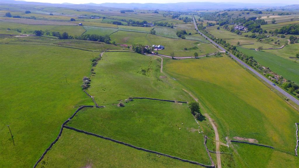
An exciting opportunity to purchase a ring fenced block of productive meadow and pasture grassland extending to approximately 28.20 hectares (69.69 acres). The land is situated in a desirable and accessible location within the Yorkshire Dales National Park, to the east of the Lake District.
LOCATION
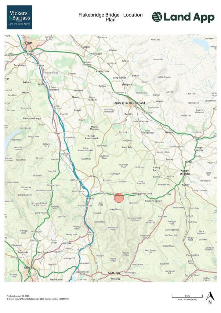
Flakebridge Farm is situated within the Yorkshire Dales National Park, approximately 3.5 miles to the east of Tebay and 8.5 miles west of Kirby Stephen. The farm is ideally situated to take advantage of major road networks, being 3 miles to the M6 and 12.5 miles to the A66.
Local amenities can be found in Kirby Stephen, however larger towns with a range of facilities including supermarkets, restaurants, medical centres are at Kendal (16 miles), Penrith (22 Miles), Lancaster (35 miles) and Carlisle (40 miles).
The farm is also very well placed for education facilities; primary schools are located 4 miles away in Tebay and Orton, Kirby Stephen is 8 miles to the north. The prestigious Sedbergh school is located 15 miles to the south in the town of Sedbergh. Secondary schools include Settlebeck School in Sedbergh, Kirby Stephen Grammar School and Appleby Grammar School. Furthermore, the university of Lancaster is 35 miles to the south.
What3 words: couriers.glassware.belong
ACCESS
From the M6, exit at junction 38 and head east for 3.5 miles on the A685. From the east, exit the A66 at Brough and head south on the A685 towards Kirkby Stephen for 13 miles.
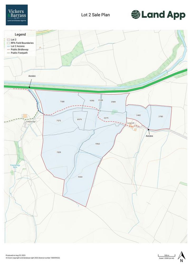
Lot 2 will be accessed through Lot 1 as shown by the blue line on the Steading and Sale Plans and also from the east, from the unnamed road heading west from Bowderdale.
DESCRIPTION
LOT 2 - 28.20 hectares (69.69 acres) predominantly meadow and some pasture and moorland
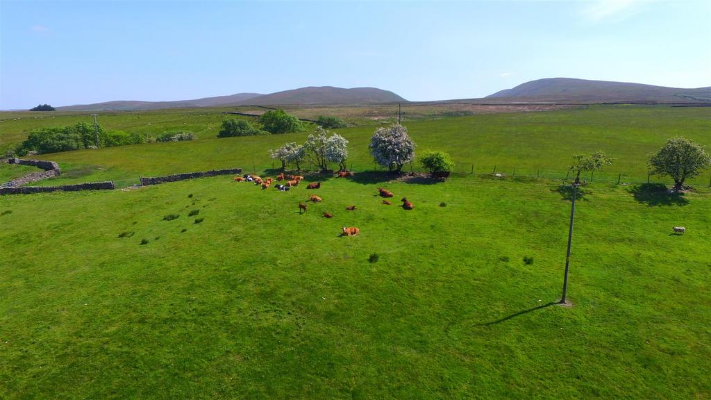
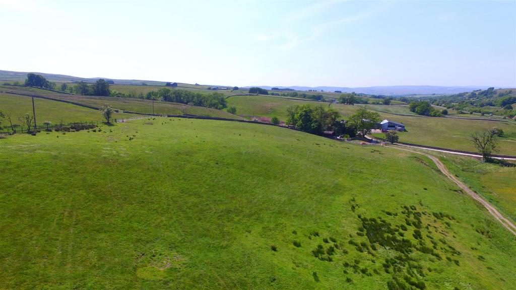
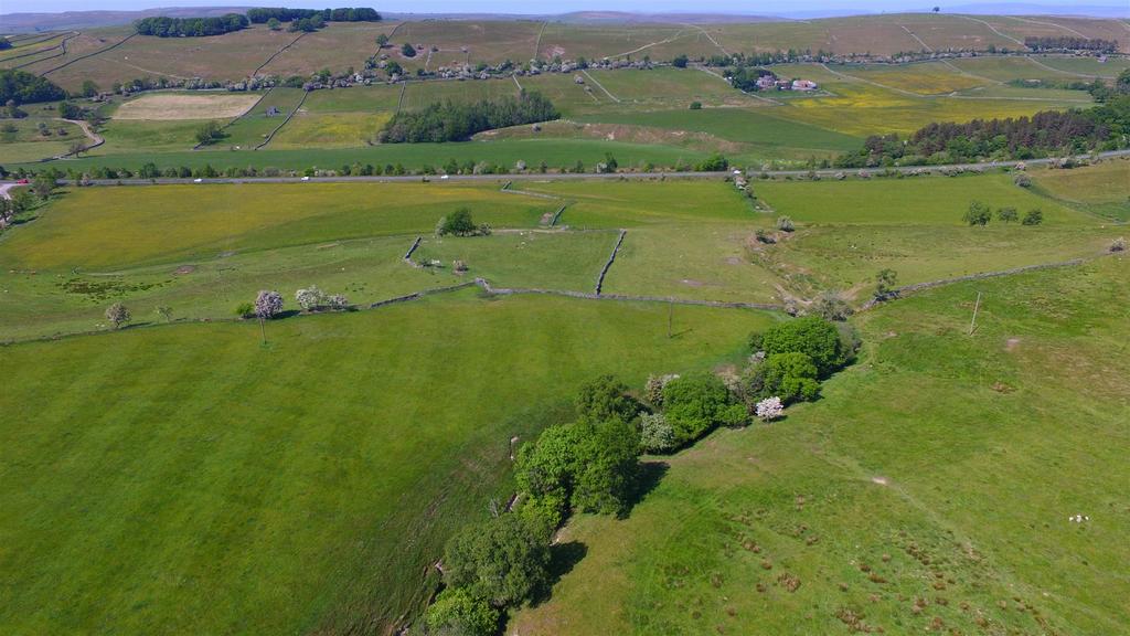
The land is in good heart and is currently very well managed and farmed. It extends to 28.20 hectares (69.69 acres) in total. The most northerly parcels are all productive, high yielding meadow fields some of which have recently been sown with a legume grass mix. As the land continues to the south the elevation increases, there are permanent pasture fields with the most southerly parcel being classed as moorland. The boundaries are mainly stone walls, the majority of which are in excellent condition, having been recently improved by the current owners. Several of the fields to the north have a mains water connection and the remaining fields are served by a natural water supply.
The land is classified as Grade 4 and the moorland parcel is classified as Grade 5.
COUNTRYSIDE STEWARDSHIP
The land is subject to a Mid Tier Countryside Stewardship Scheme, ending on 31 December 2023 and Upland Wildlife offer, ending on 31 December 2026. Full details of the schemes can be obtained from the selling agent.
PUBLIC RIGHTS OF WAY
The farm is subject to public rights of way; a bridleway leads down the drive and heads east crossing parcels 7588, 9590 and 0279, this is shown by a red dashed line on the Sale Plan. A public footpath continues up the driveway and heads west, out of the farmyard, this is shown by a green dashed line on the Sale Plan.
SPORTING & MINERAL RIGHTS
The sporting and mineral rights are excepted.
BOUNDARIES
There is a separate sale plan identifying the boundaries by inwards facing T marks, please ask the agent if you require a copy.
COSTS
Each party is to bear their own costs.
MONEY LAUNDERING
Prospective buyers should be aware that in the event that they are successful they will be required to provide documents in relation to the current Money Laundering and Terrorist Financing Regulations. The extent of the required documentation will be confirmed to the purchaser(s) after acceptance of an offer.
TENURE
We are informed by the current vendors that the property is held freehold.
METHOD OF SALE
The property is offered for sale as a whole or in three lots by private treaty.
VIEWINGS
Please contact Vickers & Barrass Darlington office on[use Contact Agent Button] to arrange a viewing, which are strictly by appointment only.
LOCAL AUTHORITY
Westmorland & Furness Council
[use Contact Agent Button]
Planning - Yorkshire Dales National Park
[use Contact Agent Button]
BUYERS PACK
Countryside stewardship scheme
Title
Boundary Plan
NOTES
Particulars prepared - June 2023
Photographs taken - June 2023
LOCATION
Flakebridge Farm is situated within the Yorkshire Dales National Park, approximately 3.5 miles to the east of Tebay and 8.5 miles west of Kirby Stephen. The farm is ideally situated to take advantage of major road networks, being 3 miles to the M6 and 12.5 miles to the A66.
Local amenities can be found in Kirby Stephen, however larger towns with a range of facilities including supermarkets, restaurants, medical centres are at Kendal (16 miles), Penrith (22 Miles), Lancaster (35 miles) and Carlisle (40 miles).
The farm is also very well placed for education facilities; primary schools are located 4 miles away in Tebay and Orton, Kirby Stephen is 8 miles to the north. The prestigious Sedbergh school is located 15 miles to the south in the town of Sedbergh. Secondary schools include Settlebeck School in Sedbergh, Kirby Stephen Grammar School and Appleby Grammar School. Furthermore, the university of Lancaster is 35 miles to the south.
What3 words: couriers.glassware.belong
ACCESS
From the M6, exit at junction 38 and head east for 3.5 miles on the A685. From the east, exit the A66 at Brough and head south on the A685 towards Kirkby Stephen for 13 miles.
Lot 2 will be accessed through Lot 1 as shown by the blue line on the Steading and Sale Plans and also from the east, from the unnamed road heading west from Bowderdale.
DESCRIPTION
LOT 2 - 28.20 hectares (69.69 acres) predominantly meadow and some pasture and moorland
The land is in good heart and is currently very well managed and farmed. It extends to 28.20 hectares (69.69 acres) in total. The most northerly parcels are all productive, high yielding meadow fields some of which have recently been sown with a legume grass mix. As the land continues to the south the elevation increases, there are permanent pasture fields with the most southerly parcel being classed as moorland. The boundaries are mainly stone walls, the majority of which are in excellent condition, having been recently improved by the current owners. Several of the fields to the north have a mains water connection and the remaining fields are served by a natural water supply.
The land is classified as Grade 4 and the moorland parcel is classified as Grade 5.
COUNTRYSIDE STEWARDSHIP
The land is subject to a Mid Tier Countryside Stewardship Scheme, ending on 31 December 2023 and Upland Wildlife offer, ending on 31 December 2026. Full details of the schemes can be obtained from the selling agent.
PUBLIC RIGHTS OF WAY
The farm is subject to public rights of way; a bridleway leads down the drive and heads east crossing parcels 7588, 9590 and 0279, this is shown by a red dashed line on the Sale Plan. A public footpath continues up the driveway and heads west, out of the farmyard, this is shown by a green dashed line on the Sale Plan.
SPORTING & MINERAL RIGHTS
The sporting and mineral rights are excepted.
BOUNDARIES
There is a separate sale plan identifying the boundaries by inwards facing T marks, please ask the agent if you require a copy.
COSTS
Each party is to bear their own costs.
MONEY LAUNDERING
Prospective buyers should be aware that in the event that they are successful they will be required to provide documents in relation to the current Money Laundering and Terrorist Financing Regulations. The extent of the required documentation will be confirmed to the purchaser(s) after acceptance of an offer.
TENURE
We are informed by the current vendors that the property is held freehold.
METHOD OF SALE
The property is offered for sale as a whole or in three lots by private treaty.
VIEWINGS
Please contact Vickers & Barrass Darlington office on[use Contact Agent Button] to arrange a viewing, which are strictly by appointment only.
LOCAL AUTHORITY
Westmorland & Furness Council
[use Contact Agent Button]
Planning - Yorkshire Dales National Park
[use Contact Agent Button]
BUYERS PACK
Countryside stewardship scheme
Title
Boundary Plan
NOTES
Particulars prepared - June 2023
Photographs taken - June 2023
Property information from this agent
About this agent
Vickers & Barrass Chartered Surveyors - Darlington
Humbleton Park, West Auckland Road
Darlington
DL2 2YH
01325 617396Vickers and Barrass are a firm of Rural Chartered Surveyors and Estate Agents offering a professional land agency and surveying service throughout the North East of England to farmers, estates and land owners alongside a professional sales and lettings service for residential and commercial property throughout the region. T H Vickers Limited was originally established by Harry Vickers in 1973. In September 2012 the business was acquired by Darlington Farmers Auction Mart Limited to provide a land agency service and the brand name of Vickers and Barrass was formed. In August 2018 the firm expanded further to merge with Broadley and Coulson. Vickers and Barrass is now managed by Adam Barrass MRICS FAAV. Our Client Money Protection (CMP) is with the RICS Client Money Protection Scheme and Redress scheme is with Ombudsman Service:Property.